Your cart is currently empty!
American Built, Affordable Price. Check out the all new TrueView1 LITE
Mapping & Survey
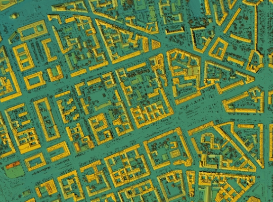
Drones are rapidly transforming geospatial and surveying practices, offering unprecedented efficiency and accuracy. While historical limitations hindered their widespread adoption, recent technological advancements have solidified their position as indispensable tools. Innovations like onboard Real-Time Kinematic (RTK) positioning, high-resolution cameras, and extended battery life have significantly enhanced data precision and operational capabilities.
Modern drones are deployed to generate a wide array of geospatial products, including highly accurate topographic maps, detailed contour elevation maps, precise volume measurements, and immersive 2D and 3D models. The benefits are substantial, encompassing reduced fieldwork and post-processing time, enhanced worker safety by minimizing exposure to hazardous environments, and significantly improved data accuracy.
Photogrammetry, a long-established technique in mapping and surveying, continues to be a valuable asset. However, its efficacy can be compromised in areas with dense vegetation or tree cover. This is where Light Detection and Ranging (LiDAR) technology, integrated into advanced drone platforms, provides a crucial advantage. LiDAR’s ability to penetrate vegetation and capture detailed ground surface data enables accurate surveying in challenging environments, replacing traditional, time-consuming methods.
Expanding on Modern Applications and Benefits:
- High-Accuracy Topographic Mapping: Drones equipped with RTK/PPK (Post-Processed Kinematic) systems achieve centimeter-level accuracy, producing detailed topographic maps for various applications, including construction, infrastructure planning, and environmental monitoring.
- Precise Volume Calculations: Drones quickly and accurately calculate volumes of stockpiles, excavations, and other earthworks, streamlining material management and cost estimation.
- 3D Modeling and Digital Twin Creation: Drones capture high-resolution imagery and LiDAR data to generate detailed 3D models of terrain and infrastructure, creating digital twins for analysis and visualization.
- Corridor Mapping: Drones are used to map linear infrastructure corridors, such as roads, railways, and pipelines, efficiently capturing detailed information for planning and maintenance. Beyond Visual Line of Sight (BVLOS) waivers permit more applications for corridor mapping.
- Environmental Monitoring and Analysis: Drones monitor erosion, track vegetation changes, and assess environmental impacts, supporting environmental management and conservation efforts.
- Disaster Response and Damage Assessment: Drones rapidly assess damage after natural disasters, providing critical information for emergency response and recovery operations.
- Improved Safety: By replacing traditional ground-based surveying methods in hazardous areas, drones minimize risks to personnel.
- Increased Efficiency: Drones significantly reduce fieldwork time and post-processing effort, accelerating project timelines and reducing costs.
- Enhanced Data Density and Resolution: Drones capture high-resolution data with greater density than traditional methods, providing a more detailed and accurate representation of the surveyed area.
- Cost Efficiency: Drones drastically reduce the cost of surveying and mapping projects when compared to traditional methods.
Expertise in drone-based mapping and surveying is crucial for optimizing data acquisition and processing. Seiler GeoDrones offers valuable guidance in selecting the appropriate drone platforms and sensors, ensuring clients avoid costly errors and achieve optimal results. This is who we are, after all it is in our name.
Related Products
-
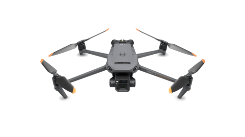 DJI Mavic 3 Enterprise
 -
 70GP Unlimited$14,000.00
 -
40GP Unlimited$9,000.00
-
110 Pack Credits$20,000.00
-
55 Pack Credits$11,000.00
-
30 Pack Credits$8,000.00
-
15 Pack Bundle$6,000.00
-
 Annual Platform License – Scale$7,500.00
 -
 Annual Platform License – Standard$4,000.00
 -
 PIX4Dsurvey Essentials Online Training Course$290.00
 -
PIX4Dmatic Essentials Online Training Course + Certification Exam$406.00
-
PIX4Dmatic Essentials Online Training Course$290.00
-
PIX4Dmatic Essentials Certification Training Exam$290.00
-
PIX4Dmapper In-Depth Online Training Course$290.00
-
PIX4Dmapper Essentials Certification Exam Training$290.00
-
PIX4Dfields Essentials Online Training Course + PIX4Dfields Essentials Certification Exam$406.00
-
PIX4Dfields Essentials Online Training Course$290.00
-
PIX4Dfields Essentials Certification Exam Training$290.00
-
PIX4Dcatch – PIX4Dcloud Advanced Workflow Online Training Course$290.00
-
PIX4Dcatch – Desktop Workflow Online Training Course$290.00
-
PIX4Dcatch – Cloud Workflow Online Training Course$290.00
-
PIX4Dcatch – Cloud and Desktop Workflow Online Training Course$290.00
-
Collision Reconstruction Online Training Course With PIX4Dmatic$290.00
-
PIX4Dcloud Yearly Rental$590.00