Your cart is currently empty!
American Built, Affordable Price. Check out the all new TrueView1 LITE
Wingtra LIDAR Payload + Software for 1 Year
$44,000.00
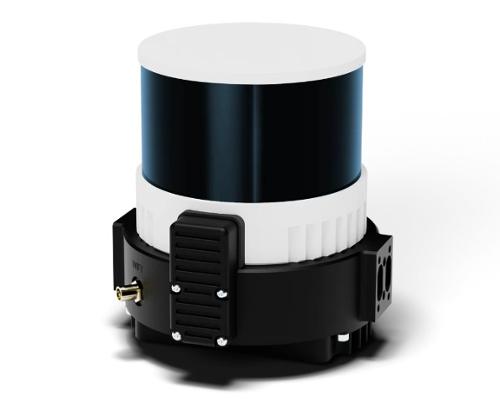
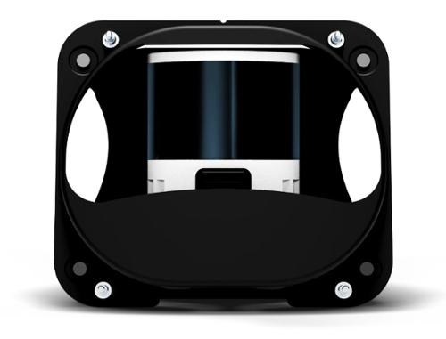
The Wingtra LIDAR Payload, available through Seiler GeoDrones, integrates a Hesai scanner, Inertial Labs IMU, and NovAtel GNSS for high-precision data collection, offering seamless integration with WingtraOne GEN II drones for efficient aerial mapping and LiDAR scanning.
Description
The Wingtra LIDAR Payload, offered by Seiler GeoDrones, is a cutting-edge solution that enhances your WingtraOne GEN II drone for high-accuracy aerial mapping and LiDAR scanning. This state-of-the-art payload includes a Hesai scanner, Inertial Labs IMU, and NovAtel GNSS, providing an integrated, high-performance system for precise data capture in a variety of environments.
The Hesai scanner emits a 905nm laser pulse and operates at a class 1 laser rating, ensuring eye-safe operation. The scanner provides an impressive point rate of 480,000 pts/second for the 3rd return, translating to 160k pts/second for a single return, offering exceptional point density for detailed scans. With effective point density at 90m AGL, the payload delivers:
- Hard surfaces: ~110 pts/m² (single return)
- Low vegetation: Up to 220 pts/m² (dual return)
- High vegetation: Up to 330 pts/m² (triple return)
The NovAtel GNSS module ensures precise georeferencing with up to 0.5cm positioning accuracy, using GPS, GLONASS, BEIDOU, and GALILEO constellations for enhanced global coverage. The Inertial Labs Tactical Grade IMU-P module defines the sensor orientation (pitch, roll, yaw), ensuring the captured data is accurate and usable, making the Wingtra LIDAR highly reliable for mapping complex environments like forests, vegetation, and urban areas.
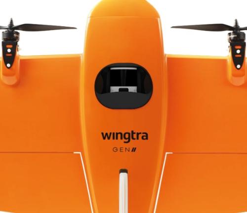
This advanced payload is fully integrated with the WingtraOne GEN II drone, which provides power and command signals for autonomous operation, ensuring efficient data collection for both surveying and aerial mapping. With the ability to cover up to 360 hectares at 90m altitude (300ft) with 30% side overlap, this system is ideal for large-scale projects.
The included Wingtra LiDAR Annual Software License provides full access to Wingtra’s powerful LiDAR software for a year, which includes key features such as PPK Path Alignment, LAS and LAZ file generation, and path correction tools, ensuring accurate, reliable LiDAR data every time. The software also provides regular updates and technical support, making it a valuable tool for optimizing aerial LiDAR mapping operations.
With the Wingtra LIDAR Payload, you can achieve precision results in forest mapping, large-scale terrain analysis, and detailed geospatial data collection. This system is perfect for surveying professionals, forestry experts, and anyone looking to perform high-resolution LiDAR scans using the WingtraOne GEN II drone.
Related products

Wingtra MAP61 Payload (GEN II)
$11,500.00
Wingtra Sony Alpha a6100 Camera Payload Kit
$2,500.00
Wingtra Oblique Sony Alpha a6100 Camera Payload Kit
$4,500.00
Wingtra MicaSense RedEdge Panchromatic Kit
$10,900.00
Wingtra RGB61 Professional 61MP Camera Payload Kit
$10,000.00