Your cart is currently empty!
American Built, Affordable Price. Check out the all new TrueView1 LITE
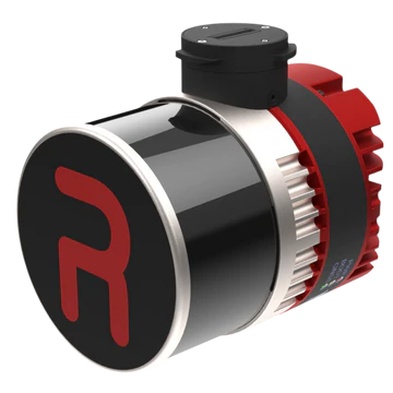
RESEPI Ultralite-XT32 (FPV gimbal)
$24,450.00
The RESEPI Ultralite-XT32 with FPV Gimbal, available through Seiler GeoDrones, is a lightweight and high-precision LiDAR and imaging system with an integrated FPV gimbal, designed for efficient, stabilized aerial data collection and mapping.
Description
The RESEPI Ultralite-XT32 with FPV Gimbal, offered by Seiler GeoDrones, is a compact and versatile LiDAR and imaging system built for high-accuracy mapping, surveying, and industrial inspections. Featuring the XT32 LiDAR sensor, this system captures dense, high-resolution 3D point clouds for topographic mapping, vegetation analysis, and environmental monitoring. The integrated FPV gimbal ensures stable, real-time visual feedback, enhancing flight control and situational awareness. Weighing just 1.9 lbs, the Ultralite-XT32 is designed for easy integration with UAV platforms, offering maximum portability without compromising on performance. Whether for precision surveying, infrastructure inspection, or remote sensing, the RESEPI Ultralite-XT32 delivers superior data quality, reliability, and operational efficiency for mission-critical applications.
Related products

PIX4Dcatch Professional Yearly Rental
$1,590.00
TrueView 625 Traditional + Software
$90,000.00
Wingtra RGB Payload Top Cover for WingtraOne Drone
$170.00
RESEPI Ouster REV7 OS1-64
$46,650.00
RESEPI Teledyne EchoONE 5MP Camera (FPV Gimbal)
$61,350.00